Kachemak Bay Watershed Collaborative

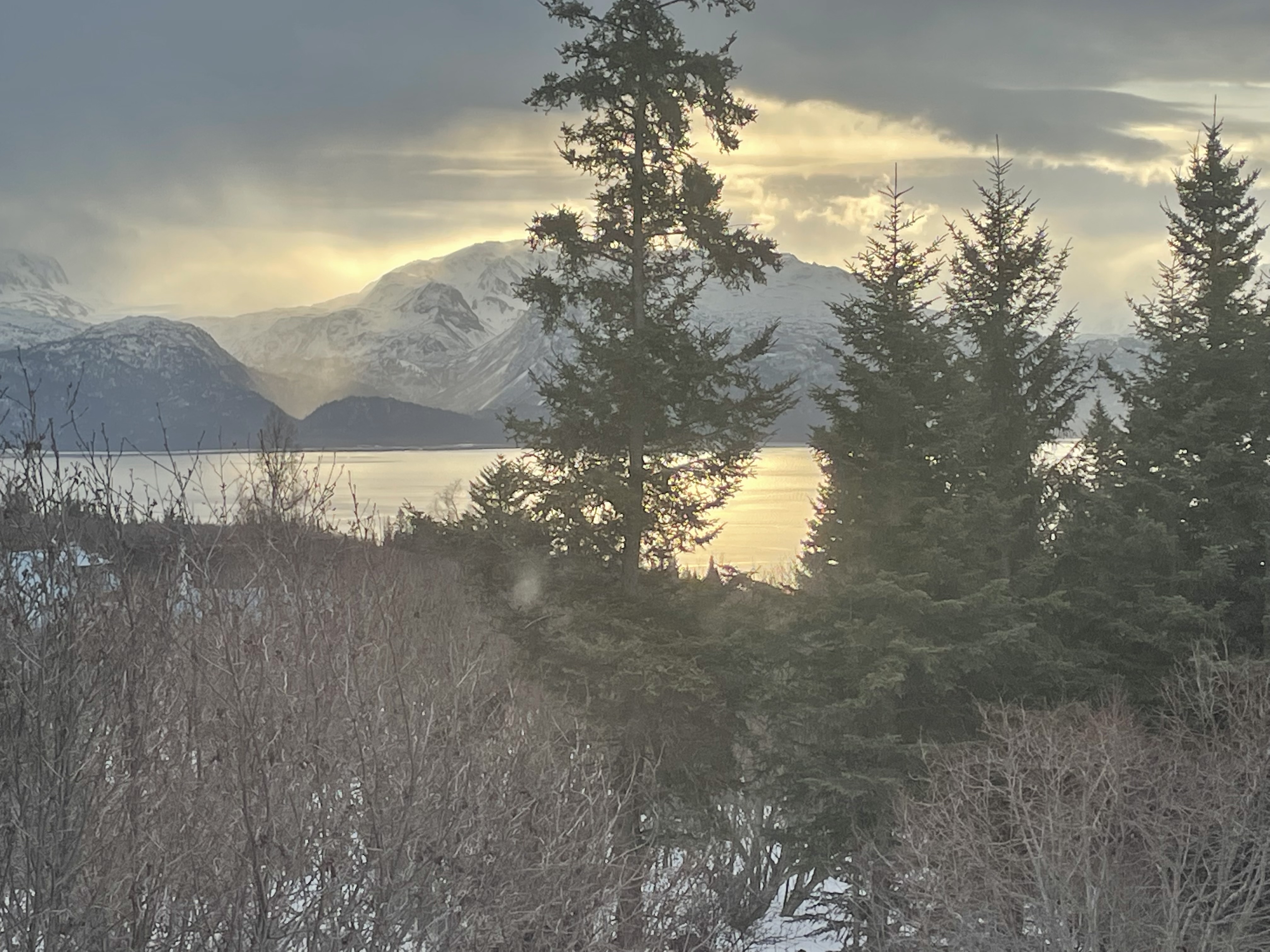
Kenia Mountain Range & Kachemak Bay


The Chugach Regional Resource Commission (CRRC) is an Alaska Native Tribal consortium in south-central Alaska whose Dena’ina, Alutiiq, and Sugpiaq villages and association members have stewarded of the Kachemak Bay watershed for over 10,000 years. CRRC’s mission is to promote Tribal sovereignty and protect subsistence lifestyles through the development and implementation of Tribal natural resource management programs to assure conservation and sustainable economic development in the traditional use area of the Chugach Region.
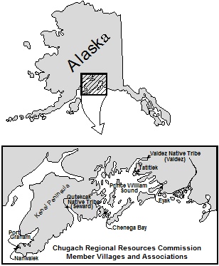
CRRC Tribes Map

CRRC serves the greater Chugach region of Southcentral Alaska, including Lower Cook Inlet, Resurrection Bay, and Prince William Sound. Within Lower Cook Inlet CRRC will work with area member tribes to establish the Kachemak Bay Watershed Collaborative (Collaborative or KBWC) to protect salmon streams located within the Kachemak Bay Watershed (Watershed). The Athabascan and Sugpiaq communities located within the Watershed rely on a subsistence economy, as they have since time immemorial.

CRRC will engage a diverse group of stakeholders with land ownership or authority within the Watershed, including Federally recognized Tribal entities, the U.S. Fish and Wildlife Service, the Alaska Departments of Natural Resources and Fish and Game, the municipalities of Homer, Kachemak Selo, Voznesenka and Razdolna, Seldovia and the unincorporated Native village communities of Nanwalek and Port Graham, and conservation organizations.

Many changes related to warming fresh and marine water temperatures impact the subsistence resources. Increasingly common drought conditions and spruce beetle outbreaks in the region threaten the health of the plants and animals rural communities rely upon for subsistence. These changes are happening at a rate no one thought possible even a decade ago. Land management activity within the Watershed can exacerbate such impacts. The Collaborative will work to be more inclusive of tribal and other local communities along with local, state, and federal stakeholders in monitoring, planning, and decision-making within the Watershed. The implementation of risk assessments and planning documents, along with preserving connectivity and non-climate stressor mitigation actions, will ensure better protection and management of salmon habitat in the Watershed.

Project location 

The 4,926,794-acre Watershed is made up of five small watersheds located in the Kenai Peninsula Borough within the state of Alaska and encompasses the municipalities of Homer, Kachemak Selo, Voznesenka, Razdolna, Seldovia, and the unincorporated Alaska Native village communities of Nanwalek and Port Graham. The United States Geological Survey (USGS) Hydrologic Unit Codes (HUC) in which the group will work are: Cook Inlet, Stariski Creek-Frontal Cook Inlet, Fox River, Sheep Creek and Quiet Creek-Frontal Kachemak Bay Watershed HUC ID #s: 1902080000, 1902030108, 1902030110, 1902030109 and 1902030111 respectively.

Technical project description 

There is currently is no group focused specifically on this Watershed, although a diverse array of stakeholders, including livestock grazers, tourist and recreation groups, industry, environmental organizations, recreation advocates, universities, land use, tribal, state and federal entities, municipalities and the general public utilize the area. This Watershed group will also help fill a planning gap left by the elimination of Alaska’s Coastal Zone Management program.

There are several ongoing or previous watershed planning activities, projects, or efforts related to the Watershed that the Collaborative will build upon, including:

  • The Kachemak Bay Fox-River Climate Risk Assessment analyzes current threats to salmon habitat within a portion of the Watershed, addresses salmon habitat connectivity and climate resiliency for the entire Watershed, and works with federal and state resource agencies to enter into cooperative agreements for management of salmon habitat on a watershed basis;
  • The Alaska Department of Fish and Game Fox River Flats Critical Habitat Area (FRFCHA) management plan addresses regulatory management goals for the FRFCHA and includes managing the area to 1) maintain and enhance fish and wildlife populations and their habitat; 2) minimize the degradation and loss of habitat values due to fragmentation, and; 3) recognize cumulative impacts when considering effects of small incremental developments and action affecting critical habitat resources.
  • The Kachemak Heritage Land Trust’s (KHLT) Krishna Venta Conservation Management Plan addresses working collaboratively with state, federal, and local entities as KHLT purchases and negotiates conservation easements on private lands for the purposes of management and protection of fish and wildlife habitat of KHLT’s 160 acres in the FRFCHA;
  • The Kenai Mountains To Sea – Land Conservation Strategy to Sustain Our Way of Life on the Kenai Peninsula calls for the creation of contiguous “green” corridors along 20 inter-jurisdictional anadromous streams, most of which originate on the Kenai Refuge. Such protection will increase the resiliency of these streams and the marine habitat into which they feed from the effects of a rapidly warming climate while ensuring that large piscivores such as brown bears and wolves persist to transport marine derived nutrients onto the landscape;
  • The Department of Natural Resources’ Kachemak Bay State Park and Kachemak Bay State Wilderness Park Management Plan addresses management of the 371,000- acre Kachemak Bay State Park and Kachemak Bay State Wilderness Park (State Park);
  • The Cook Inlet Keeper State of the Inlet watershed restoration plan within the Watershed captures threats and community-specific concerns and ideas to help direct CIK’s watershed-based organization as the plan future projects.

Join the Collaborative:

If you are a federal, state, or tribal entity, conservation group, or anyone else interested in the welfare and sustainability of Kachemak Bay, please join our Collaborative. If you have any questions please contact Hal Shepherd halshepherdwpc@gmail.com

Last Stand for the Tongass

The Tongass National Forest, the largest national forest in the United States, is a landscape comprised of old-growth Sitka spruce, western hemlock, and red and yellow cedar. These mighty trees, along with innumerable glacially-fed streams and lakes, give rise to all five species of Pacific salmon, humpback whales, healthy black and brown bear populations, wolves, and omnipresent bald eagles. Located in southeastern Alaska, the 17 million acre Tongass is the size of West Virginia and home to 70,000 people, including the First Nation people of the Tlingit, Haida, and Tsimshian, and the city of Juneau, Alaska’s state capital. It is also the largest expanse of roadless wilderness in the national forest system, at least for now.

Protected by the 2001 Roadless Area Conservation Rule (signed into effect by President Bill Clinton), 55% of the Tongass, or 9.2 million acres, is off limits to road construction and timber sales.  But, in January 2018, under Governor Bill Walker’s administration and with the backing of the Trump Administration, the State of Alaska petitioned the Secretary of Agriculture to consider exempting the Tongass from the Roadless Rule.

Under the federal National Environmental Policy Act, any consideration to exempt the Tongass from the Roadless Rule requires a 60-day public comment period and a scientific analysis of environmental impacts to the Tongas. The 60-day public comment period, conducted this summer, fell well short of its obligation according to tribal members who received last-minute notice of public meetings. In their opinion, the comment period “exemplifies the federal government’s long-running failure to adequately work with tribes.” In response, eleven southeast Alaskan tribes vested in the outcome of the upcoming ruling, filed a petition in July, requesting the USDA consult with tribes “on a government-to-government basis.” Earlier attempts by area tribes to engage in the two-year process were derailed because “the USDA repeatedly ignored their input and requests for in-person meetings; fast-traced seemingly arbitrary deadlines; and proceeded as usual despite a pandemic that has disproportionally hurt Native communities.”

The Final Environmental Impact Statement (EIS), was released on September 24, 2020 and analyzes six alternatives, including a no-action alternative. Trump-appointed USDA Secretary Sonny Perdue prefers Alternative 6 which “provides maximum additional timber harvest opportunities,” removing “all 9.37 million inventoried roadless acres on the Tongass from roadless designation.” Moreover, “Alternative 6 would revert a net total of 168,000 old growth-acres and 20,000 young-growth acres, previously identified as unsuitable timber lands, to suitable timber lands”. The Tongas will “continue to be managed by the Forest Plan and in accordance with applicable statutory instructions.” There is a 30-day waiting period following the release of the EIS prior to implementation to allow for review.

If you want to weigh in against opening up the Tongas, please see the following websites.

https://addup.sierraclub.org/campaigns/keep-alaskas-tongass-national-forest-roadless

https://act.nrdc.org/letter/tongass-forest-181004

Your voice matters.

Public Lands Management Under Trump Descends into Chaoss


President Donald Trump’s appointment of William Perry Pendley as Director of the Bureau of Land Management who is openly hostile to environmental regulations, has turned into yet another legal debacle typical of the current administration. Pendley’s inflammatory statements and open opposition to social justice and diversity including for native and African American communities, statements that public lands should be privatized, conflicts of interest, unethical conduct, support of anti-government extremists and efforts to dismantle the BLM, have outraged conservation and tribal organizations throughout the western U.S. It, therefore, quickly became obvious to Interior Secretary David Bernhardt that because of Pendley’s record, there would be no way he would obtain confirmation from congress if the administration did what was legally required and nominate him for that purpose. In fact, in a procedure that the U.S. Supreme Court calls a “critical structural safeguard” of democracy, the Appointments Clause of the Constitution requires that the heads of prominent federal agencies be nominated by the President and confirmed by the Senate” a standard that is also found in the federal Vacancies Reform Act.

Especially when it comes to dismantling environmental regulatory standards, however, the Trump administration has never  been that concerned with federal law or, for that matter the U.S. Constitution and Bernhardt resolved the issue of Pendley’s radical anti-public land views, racism and support of extremists simply by repeatedly extending Pendley’s appointment as Director of the agency for the past 13 months.

As a result, in July 2020, the state of Montana and several conservation organizations filed a lawsuit to enjoin Bernhardt from continuing to extend Pendley’s status as Acting Director of BLM. This prompted Trump to finally put Pendley’s name before congress as required only to almost immediately remove it because of concerns of several republican senators in key states who are up for election about the audacity of the appointment. However, rather than remove Pendley as acting Director in accordance with with the law, Secretary Bernhardt announced that Pendley will “stay on leading BLM” as the bureau’s deputy director of policy and programs, who is also “exercising the authority of director.”

This, once again, got the attention of the Montana U.S. District Court which as part of the lawsuit filed by the state and conservationists a couple months before, promptly enjoined Pendley from exercising such authority and Bernhardt from unlawfully delegating the authority of the BLM director to him. In fact, the Court’s declaration that Pendley served unlawfully as the Acting Director of the BLM for well over a year, also meant that many of the decisions he made during that time were similarly illegal, threatening Trump’s strategy to dismantle protections of public lands and open them up to development.

Chief Judge Brian Morris found that “’any function or duty’ of the BLM Director that has been performed by Pendley would have no force and effect and must be set aside as arbitrary and capricious” and instructed DOI to compile any such acts and provide a full report to the Court. Therefore, any of the official actions Pendley took over the 424 preceding the decision including opening up the Arctic National Wildlife Refuge or the National Petroleum reserve to oil drilling,” or vast acreages of public lands, including areas relied on by Native village communities for subsistence, to mining, are potentially unauthorized.


Lawsuits Filed on ANWR

Three lawsuits have been filed seeking to block the Trump administration’s efforts to sell oil leases in the Arctic National Wildlife Refuge. The National Audubon Society, Natural Resources Defense Council, Friends of the Earth, and Center for Biological Diversity have signed off on a lawsuit sighting insufficient concern over increased greenhouse gas emissions and melting permafrost, poor air quality, and negative impacts to the region’s wildlife.  The lawsuit alleges violations of the National Environmental Protection Act, the National Wildlife Refuge System Administration Act, and the Endangered Species Act. A second lawsuit, filed by the Gwich’in Steering Committee also sites violations of the Alaska Native Claims Settlement Act, and includes plaintiffs in Canada’s Yukon chapter of Canadian Parks and Wilderness Society. Most recently, a third lawsuit was put forth by fifteen states including California, Connecticut, Delaware, Illinois, Maine, Maryland, Massachusetts, Michigan, Minnesota, New Jersey, New York, Oregon, Rhode Island, Vermont and Washington. Concerns addressed in this lawsuit include habitat damage and greenhouse gas emissions, as well as impacts to waterfowl hunting and a lucrative birdwatching industry for birds that breed on the Arctic plain and overwinter in the lower 48 states.

Read more and more.

WPC Developing Panel on Impacts of Rising Stream Temperatures and Development at American Water Resources Association Annual Meeting

Salmon Die-Off Tubutulik River in Western Region, Alaska

WPC is convening a session topic entitled “The Impacts of Mining and Climate Change on Rising Stream Temperatures in Alaska” for the American Water Resources Association’s Annual Meeting taking place in Orlando, Florida from November 3-6. 

In the summer of 2019, due to dramatic temperatures increases, thousands of salmon died throughout Alaska as they migrated to spawning grounds, because the water exceeded lethal temperature limits. These climate related stressors are further exacerbated by state and federal lands that are being opened to mining and related development on fish and wildlife populations.

The Session will address the impacts of increasing water temperatures in watersheds affected by land releases and therefore, the combined impacts of climate change and mining development on subsistence resources in Alaska including: 1) Application of models starting with global emission scenarios that will ultimately detect instream flows for specific subbasins and collection of instream flow, temperature and dissolved oxygen data; 2) Identify lands that include critical fish habitat and potential locate able minerals that have been opened for mining; and 3) A process for applying the modeling and data collected to assist policy makers and land managers to mitigate land uses that potentially exacerbate climate related impacts to watersheds.

Please contact us if you are interested in being a presenter on this topic and traveling to Orlando in the fall!

Tentative Presentation Topics include : 1) Forcasting drought and temperature increases and modeling stream flows in Alaska; 2) Use of Traditional Knowledge in Protecting Rivers in the Arctic; 3) Bureau of Land Management FLPMA Land Withdrawal Revocations;  Overview of 2019 Water Year in Alaska; 4) Pacific Northwest Drought Early Warning System.

Federal Subsistence Management Program Continues Temperature Monitoring Project for Subsistence Rivers

The U.S. Fish and Wildlife Service’s Federal Subsistence Management Program will continue conducting a water temperature monitoring project for the next two summers at rivers and streams throughout Alaska. This effort is associated with fisheries monitoring projects funded through the Fisheries Resource Monitoring Program (Program), and has been ongoing since 2008. According to the Program, temperature can impact fish through changes in metabolic rate, primary production, respiration, growth, decomposition, water chemistry, migration timing and susceptibility to disease. At the same time “[d]evelopment adjacent to stream habitats…as well as changes in climate can potentially cause fluctuations in water temperature beyond the behavioral and physiological tolerance of aquatic organisms, including fish, that could have a deleterious effect on their productivity and availability to subsistence users.”

Federal, State, and Tribal organizations in Alaska are currently collecting water temperature data for such subsistence streams. The Program is looking to highlight the importance of uniform data collection, standardization, and reporting, to ensure that such data is reliable for monitoring climate change and supporting conservation actions.

The Alaska Online Aquatic Temperature Site (AKOATS) platform, hosted by the University of Alaska Anchorage’s Alaska Center for Conservation Science, is currently used to make this data available to the public. The platform was developed with the idea that it would serve as a centralized location to access stream temperature monitoring data collection across Alaska.

Emergency Recovery Plan for Global Freshwater Biodiversity Loss

Covering approximately 1% of the Earth’s surface, the world’s freshwater rivers, lakes and wetlands are home to 10% of all species and more fish species than in all the oceans combined. Posing a threat to global communities who rely on rivers, lakes, and tributaries for food, water, and economic well-being, however, 83% of freshwater species and 30% of freshwater ecosystems have been lost since 1970. In response to the alarming rate of loss of freshwater ecosystems, a recently released study developed by scientists from across a spectrum of environmental and academic institutions outlines a framework for protecting such ecosystems.

Calling it an “Emergency Recovery Plan”, the study proposes six scientifically based strategies to preserve freshwater biodiversity, that have proved successful in certain locations. These solutions include: Returning rivers and streams back to their natural flows; Protecting freshwater from toxic effluents, overfishing, invasive species and mining activity; Protecting critical habitat; and Restoring river connectivity through regulation of land uses and water infrastructure. James Dalton, Director of the International Union for Conservation of Nature Global Water Program says, “all the solutions in the Emergency Recovery Plan have been tried and tested somewhere in the world: they are realistic, pragmatic and they work. We are calling on governments, investors, companies and communities to prioritize freshwater biodiversity – often neglected by the conservation and water management worlds. Now is the time to implement these solutions, before it is too late.”

For more information see press releases for Conservation International and WWF.

Radical transformation of the Pacific Arctic Includes Impacts to Freshwater

Scientists from multiple agencies, working collaboratively to supply data to the Arctic Integrated Ecosystem Research Program, are detecting rapid changes in the Bering and Chukchi Seas. These changes are driven by abnormally high water temperatures and rapid loss of sea ice (on par with climate predictions for 2040), and include high numbers of Pacific cod and pollock expanding into Arctic waters, higher concentrations of harmful algal blooms, and a sea bird die-off that began in 2014 impacting puffins, common murre and, most recently, short-tailed shearwaters. At the base of the food web, larger, high-fat copepods are declining while smaller, copepods with a lower-fat content are flourishing. This means less nutrition for Arctic cod, while, at the same time, more competition for these resources as pollock expand their range northward.

But these troubling changes are not limited to northern ocean waters. Inland, freshwater rivers in the Arctic are overheating. Record-warm temperatures in July, 2019 caused heat stress and a mass die-off in returning, pre-spawned salmon. Read more.

Indigenous Communities are Essential Part of Climate Discussion


Native Village of Elim Staff Collecting Flow Data – Tubutulik River, Western Region, Alaska

A new report released by the People’s Climate Network (PCN)— an alliance of activists, scholars and citizens from around the world, suggests that the role indigenous communities can play in mitigating the climate crisis is being overlooked. While global climate change movements make headlines and ”highly-educated people in far-off cities make policy” the People’s Climate Report, attempts to “amplifying voices from the grassroots.”

The report also highlights coexistence of forests, wildlife and local communities is highlighted to provide the perspective of local communities of the impacts of climate change and extraction industries especially mining. Such development leads to loss of forest cover, depletion of groundwater, increase in net-carbon emissions, changes in local weather patterns, loss of traditional tribal livelihoods and a collapse of various plant and animal species—all in the name of ‘development’.

The report show cases the case of Devi, India in which twenty year earlier, locals took the lead in returning health back to forest ecosystem after mining activity devastated the area. This included groups of mostly women who get up early in the morning to patrol forests in groups and digging pools and making mud dams to conserve water. Now a fully recovered forest with abundant resources including a steady supply of food and water, which has resulted in the return of the animals.

According to the report, “[t]hese natural resource dependent communities are among the poorest of the poor.” “They have not had a single day of formal education. And yet they have been the ones protecting this 200-hectare forest for the past twenty years or so.”

Similarly, Last month Hannah Panci from the Great Lakes Indian Fish and Wildlife Commission spoke at Lawrence University as part of the Spoerl Lecture Series, about climate impact and preparedness. Specifically, Panci discussed working with almost a dozen local Native American tribes, to develop a climate vulnerability assessment which combines both scientific research and traditional ecological knowledge (TEK) in order to create a vulnerability score for different species on tribal lands.

The organization gathers TEK by visiting the various communities, which include members that still make their living off hunting, gathering and fishing, and interviewing community these members about changes they are noticing about fish and wildlife they use for subsistence. Through this process, important information about traditions that have been passed down for generations and which species are the most important to the tribes. According to Panci, two of the main ones are wild rice and walleye, but there are 11 primary species that tribal members are concerned about.

The Great Lakes Indian Fish and Wildlife Commission then applies this information to determine what impacts climate change is having on these species and apply current scientific data to create maps of the region where such impacts are occurring and apply protection measures. By combining conventional science and local knowledge of locals is the best possible means for assisting tribal communities in the Great Lakes to prepare for climate change.

Finally, during a recent event at UC Davis in March 12, professor Beth Rose Middleton who is chair of the Native American Studies Department and Fellow at the John Muir Institute of the Environment, discussed “Tribal Leadership in Climate Change Adaptation.” Professor Middleton discussed the leadership in environmental policy and planning provided by California Indian nations in traditional including land stewardship and interventions in state, national and international policy. Middleton’s research includes Native land trusts, Native-led conservation land acquisitions, tribal participation in the carbon credit market and the importance of re-introducing traditional fire management.


Five-Year University of Alaska Study Measures Climate-Related Impacts to Coastal Streams and Forest Fire Risks.

An ambitious effort to quantify climate-driven impacts on both glacially-fed coastal ecosystems and Alaska’s fire-prone boreal forest is under way.  A new round of funding through the National Science Foundation’s Established Program to Stimulate Competitive Research (EPSCoR) was awarded in October 2018 to collaborating faculty at UAF, UAA and UAS. The 5-year, $20-million-dollar project, entitled Fire and Ice: Navigating Variability in Boreal Wildfire Regimes and Subarctic Coastal Ecosystems, is now prepping for a second summer of field work.

In Kachemak Bay (south-central Alaska) and Lynn Canal (south-eastern Alaska) researchers are evaluating changes in ocean temperature and chemistry in both glacial and non-glacial coastal ecosystems. Stream monitoring, including temperature, sedimentation, and flow measurements began in the spring of 2019 and will continue throughout the granting period. Additionally, researchers are collecting isotope measurements to help identify the sources of water in a given stream (e.g., glacial, snow-melt, groundwater or rainfall). The data will contribute to a greater understanding of the freshwater input into Alaska’s estuarine systems and the effects of continued climate change on these highly-productive ecosystems.

Throughout Alaska’s extensive boreal forest, Fire and Ice researchers are investigating fire activity and associated climate-related impacts. Data will contribute to improved community risk-assessments through modeling to predict lightning probabilities, assess available fuels, and evaluate seasonal climate forecasting in order to better predict fire risks and severity.

EPSCoR’s Fire and Ice project also includes a rigorous education and communications component. To learn more, visit: https://www.alaska.edu/epscor/fire-and-ice/