Kachemak Bay Watershed Collaborative

Kenia Mountain Range & Kachemak Bay


The Chugach Regional Resource Commission (CRRC) is an Alaska Native Tribal consortium in south-central Alaska whose Dena’ina, Alutiiq, and Sugpiaq villages and association members have stewarded of the Kachemak Bay watershed for over 10,000 years. CRRC’s mission is to promote Tribal sovereignty and protect subsistence lifestyles through the development and implementation of Tribal natural resource management programs to assure conservation and sustainable economic development in the traditional use area of the Chugach Region.

CRRC Tribes Map

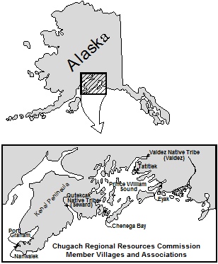
CRRC serves the greater Chugach region of Southcentral Alaska, including Lower Cook Inlet, Resurrection Bay, and Prince William Sound. Within Lower Cook Inlet CRRC will work with area member tribes to establish the Kachemak Bay Watershed Collaborative (Collaborative or KBWC) to protect salmon streams located within the Kachemak Bay Watershed (Watershed). The Athabascan and Sugpiaq communities located within the Watershed rely on a subsistence economy, as they have since time immemorial.

CRRC will engage a diverse group of stakeholders with land ownership or authority within the Watershed, including Federally recognized Tribal entities, the U.S. Fish and Wildlife Service, the Alaska Departments of Natural Resources and Fish and Game, the municipalities of Homer, Kachemak Selo, Voznesenka and Razdolna, Seldovia and the unincorporated Native village communities of Nanwalek and Port Graham, and conservation organizations.

Many changes related to warming fresh and marine water temperatures impact the subsistence resources. Increasingly common drought conditions and spruce beetle outbreaks in the region threaten the health of the plants and animals rural communities rely upon for subsistence. These changes are happening at a rate no one thought possible even a decade ago. Land management activity within the Watershed can exacerbate such impacts. The Collaborative will work to be more inclusive of tribal and other local communities along with local, state, and federal stakeholders in monitoring, planning, and decision-making within the Watershed. The implementation of risk assessments and planning documents, along with preserving connectivity and non-climate stressor mitigation actions, will ensure better protection and management of salmon habitat in the Watershed.

Project location 

The 4,926,794-acre Watershed is made up of five small watersheds located in the Kenai Peninsula Borough within the state of Alaska and encompasses the municipalities of Homer, Kachemak Selo, Voznesenka, Razdolna, Seldovia, and the unincorporated Alaska Native village communities of Nanwalek and Port Graham. The United States Geological Survey (USGS) Hydrologic Unit Codes (HUC) in which the group will work are: Cook Inlet, Stariski Creek-Frontal Cook Inlet, Fox River, Sheep Creek and Quiet Creek-Frontal Kachemak Bay Watershed HUC ID #s: 1902080000, 1902030108, 1902030110, 1902030109 and 1902030111 respectively.

Technical project description 

There is currently is no group focused specifically on this Watershed, although a diverse array of stakeholders, including livestock grazers, tourist and recreation groups, industry, environmental organizations, recreation advocates, universities, land use, tribal, state and federal entities, municipalities and the general public utilize the area. This Watershed group will also help fill a planning gap left by the elimination of Alaska’s Coastal Zone Management program.

There are several ongoing or previous watershed planning activities, projects, or efforts related to the Watershed that the Collaborative will build upon, including:

  • The Kachemak Bay Fox-River Climate Risk Assessment analyzes current threats to salmon habitat within a portion of the Watershed, addresses salmon habitat connectivity and climate resiliency for the entire Watershed, and works with federal and state resource agencies to enter into cooperative agreements for management of salmon habitat on a watershed basis;
  • The Alaska Department of Fish and Game Fox River Flats Critical Habitat Area (FRFCHA) management plan addresses regulatory management goals for the FRFCHA and includes managing the area to 1) maintain and enhance fish and wildlife populations and their habitat; 2) minimize the degradation and loss of habitat values due to fragmentation, and; 3) recognize cumulative impacts when considering effects of small incremental developments and action affecting critical habitat resources.
  • The Kachemak Heritage Land Trust’s (KHLT) Krishna Venta Conservation Management Plan addresses working collaboratively with state, federal, and local entities as KHLT purchases and negotiates conservation easements on private lands for the purposes of management and protection of fish and wildlife habitat of KHLT’s 160 acres in the FRFCHA;
  • The Kenai Mountains To Sea – Land Conservation Strategy to Sustain Our Way of Life on the Kenai Peninsula calls for the creation of contiguous “green” corridors along 20 inter-jurisdictional anadromous streams, most of which originate on the Kenai Refuge. Such protection will increase the resiliency of these streams and the marine habitat into which they feed from the effects of a rapidly warming climate while ensuring that large piscivores such as brown bears and wolves persist to transport marine derived nutrients onto the landscape;
  • The Department of Natural Resources’ Kachemak Bay State Park and Kachemak Bay State Wilderness Park Management Plan addresses management of the 371,000- acre Kachemak Bay State Park and Kachemak Bay State Wilderness Park (State Park);
  • The Cook Inlet Keeper State of the Inlet watershed restoration plan within the Watershed captures threats and community-specific concerns and ideas to help direct CIK’s watershed-based organization as the plan future projects.

Join the Collaborative:

If you are a federal, state, or tribal entity, conservation group, or anyone else interested in the welfare and sustainability of Kachemak Bay, please join our Collaborative. If you have any questions please contact Hal Shepherd halshepherdwpc@gmail.com

Governor Dunleavy Nominations Graphite Creek Project to Fast-41 Permitting


Hot Springs Creek Below the Proposed Graphite One Mine Site

Due to Alaska Governor Mike Dunleavy’s nomination of Graphite Creek project in the remote Kigluaik range north of Nome, as a high-priority infrastructure project, as eligible for new legislation intended to fast track the permitting process for transportation projects. Title 41 of the Fixing America’s Surface Transportation Act, (Fast-41) adopted by Congress during the Obama administration which was intended to be a surface transportation reauthorization focusing on highway, transit, and rail programs. The Act establishes a new Federal Permitting Improvement Steering Council (FPISC), authorized to stream line the NEPA process including elimination of public review and comment. Due to the unprecedented authority provided to the Council, until now, the Act has traditionally been applied only to Infrastructure and transportation Projects.

However, mining companies and the Trump administration have been pressuring FPISC to include mining as a sector under the Act. According to the mining industry magazine Critical Minerals Alaska 2020, “a federal entity meant to provide a one-stop-shop capable of coordinating permits across different federal agencies, thereby streamlining and shortening the overall process for large infrastructure projects that are eligible for the program.  Mining projects that supply the materials needed for the energy, communication, and transportation infrastructure in the U.S. may be eligible for Fast-41.” [1] If the proposed Graphite One Mine is included into Fast-41, Critical Minerals Alaska 2020 says it “could help reduce the seven to 10 years it takes the average large mining project in the U.S. to get through the permitting process.”[2]

The sudden surge in the mining of graphite and other precious minerals in Alaska results from a dramatic increase in demand for batteries, solar power, computers, and other high-tech products that require such minerals. For instance, graphite is a significant component of the lithium-ion batteries used for electric cars and some renewable energy systems. According to the World Bank , due to the growing global interest in such cars and energy, the demand for graphite, lithium, cobalt, and other battery metals could increase by nearly 500 percent by 2050.[1] The report says that, “[g]raphite demand increases in both absolute and percentage terms since graphite is needed to build the anodes found in the most commonly deployed automotive, grid, and decentralized batteries. ” Similarly, according the United States Geological Survey, there are currently no graphite mines in the United States, requiring American battery and other manufacturers to import 58,000 metric tons of graphite during 2019.[2]  According to CMA2020, with “5.7 million metric tons of quality graphite outlined so far, Graphite One Inc.’s Graphite Creek deposit in Northwest Alaska could provide a reliable domestic supply of graphite to North America’s burgeoning lithium-ion battery sector.” [3]

[1] Shane Lasley, High priority Alaska REE, graphite projects Gov nominations elevate mine projects to Fast-41 permitting, p. 6-7, High priority Alaska 2020 (November 2, 2020).

[2] Ibid.

[3] Shane Lasley, Western Alaska deposit could feed graphite into supply chain, Mining News, CRITICAL MINERALS ALASKA, pp. 28-29 (2020)

Last Stand for the Tongass

The Tongass National Forest, the largest national forest in the United States, is a landscape comprised of old-growth Sitka spruce, western hemlock, and red and yellow cedar. These mighty trees, along with innumerable glacially-fed streams and lakes, give rise to all five species of Pacific salmon, humpback whales, healthy black and brown bear populations, wolves, and omnipresent bald eagles. Located in southeastern Alaska, the 17 million acre Tongass is the size of West Virginia and home to 70,000 people, including the First Nation people of the Tlingit, Haida, and Tsimshian, and the city of Juneau, Alaska’s state capital. It is also the largest expanse of roadless wilderness in the national forest system, at least for now.

Protected by the 2001 Roadless Area Conservation Rule (signed into effect by President Bill Clinton), 55% of the Tongass, or 9.2 million acres, is off limits to road construction and timber sales.  But, in January 2018, under Governor Bill Walker’s administration and with the backing of the Trump Administration, the State of Alaska petitioned the Secretary of Agriculture to consider exempting the Tongass from the Roadless Rule.

Under the federal National Environmental Policy Act, any consideration to exempt the Tongass from the Roadless Rule requires a 60-day public comment period and a scientific analysis of environmental impacts to the Tongas. The 60-day public comment period, conducted this summer, fell well short of its obligation according to tribal members who received last-minute notice of public meetings. In their opinion, the comment period “exemplifies the federal government’s long-running failure to adequately work with tribes.” In response, eleven southeast Alaskan tribes vested in the outcome of the upcoming ruling, filed a petition in July, requesting the USDA consult with tribes “on a government-to-government basis.” Earlier attempts by area tribes to engage in the two-year process were derailed because “the USDA repeatedly ignored their input and requests for in-person meetings; fast-traced seemingly arbitrary deadlines; and proceeded as usual despite a pandemic that has disproportionally hurt Native communities.”

The Final Environmental Impact Statement (EIS), was released on September 24, 2020 and analyzes six alternatives, including a no-action alternative. Trump-appointed USDA Secretary Sonny Perdue prefers Alternative 6 which “provides maximum additional timber harvest opportunities,” removing “all 9.37 million inventoried roadless acres on the Tongass from roadless designation.” Moreover, “Alternative 6 would revert a net total of 168,000 old growth-acres and 20,000 young-growth acres, previously identified as unsuitable timber lands, to suitable timber lands”. The Tongas will “continue to be managed by the Forest Plan and in accordance with applicable statutory instructions.” There is a 30-day waiting period following the release of the EIS prior to implementation to allow for review.

If you want to weigh in against opening up the Tongas, please see the following websites.

https://addup.sierraclub.org/campaigns/keep-alaskas-tongass-national-forest-roadless

https://act.nrdc.org/letter/tongass-forest-181004

Your voice matters.

Unflagging Opposition to Business-as-Usual Extraction Practices


With Present Trump rolling back one environmental policy after another, ongoing efforts to slow global warming, safeguard wilderness, and provide clean water and air can seem futile. But never doubt that a handful of thoughtful, committed lawsuits can change the world. Indeed, it may be the only recourse that can.

We need look no farther than the Gwich’in Native community for inspiration when it comes to fighting to protect the environment. For more than thirty years they have resisted attempts to open up the Arctic National Wildlife Refuge to oil and gas drilling. Under Trump’s plan to open lease sales across the entire coastal plain, that fight has kicked into high gear. For the Gwich’in, the coastal plain, birthing grounds for the Porcupine caribou herd which numbers approximately 200,000, is sacred ground. Their culture, history and way of life revolve around the caribou and the 1.5 million-acre expanse of coastal lands. Sarah James, Gwich’in elder, explains, “We have a special connection in that we are a part of the caribou and the caribou are part of us. It is our language, our songs, our dance…. We take care of the caribou, and in return, they take care of us, and that’s really important to my people here.”

The Gwich’in Sterring Committee, along with several other plaintives including Canada’s Yukon chapter of Canadian Parks and Wilderness Society, filed a lawsuit in late August, seeking to overturn Trump’s approval for oil leasing, and siting violations of the Alaska Native Claims Settlement Act and likely impacts to the Porcupine Caribou Herd.

A second lawsuit to halt oil leasing on the Refuge filed by The National Audubon Society, Natural Resources Defense Council, Friends of the Earth, and Center for Biological Diversity sight insufficient concern over increased greenhouse gas emissions and melting permafrost, poor air quality, and negative impacts to the region’s wildlife.

And most recently, a third lawsuit to overturn drilling in the Arctic National Wildlife Refuge was filed on September 9th with the U.S. District Court in Anchorage by attorneys general for 15 states and led by Washington and Massachusetts. The lawsuit states that drilling will contribute to global climate change and its effects such as sea level rise and extreme weather events.

A number of other environmental legal battles continue in Alaska and Siberia. In North-western Alaska’s National Petroleum Reserve, Trump seeks to overthrow Obama-era safeguards by expanding development into regions of the Reserve long slated for protection. Two recent lawsuits are pushing back against expanded development in NPR-A oil leasing. The lawsuits are in response to the final environmental impact statement released by the Bureau of Land Management in June allowing oil leasing on 18.7 million acres in the 23-million-acre reserve, including drilling in Teshekpuk Lake. Teshekpuk is the largest lake on the North Slope and provides critical habitat for migratory waterfowl and shorebirds.

And while a lawsuit filed by the Natural Resources Defense Council challenging the U.S. Environmental Protection Agency’s reversal of restrictions on Pebble Mine was dismissed in US District Court, Alaska Senator Dan Sullivan has joined a growing rank of conservatives who are openly opposed to the Pebble mine project. The proposed gold, molybdenum and cooper mine, in South-central Alaska’s Lake and Peninsula region, is recognized as a threat to the nationally-significant Bristol Bay salmon fisheries. Following the release of secret recordings by Pebble executives, Sullivan stated in a tweet on September 24th, “Let me be even more clear: I oppose Pebble Mine. No Pebble Mine.” This follows a surprise stipulation issued by the U.S. Army Corps of Engineers in late August to Dynasty Minerals Ltd requiring the mine owners to outline how they will offset damage to wetlands and any impacts to the Bristol Bay salmon fishery. Other conservatives who oppose the mine, at least as it is currently proposed, including Alaska Senator Lisa Murkowski, Donald Trump Junior and Fox News host Tucker Carlson.

In the southern part of the state, Southeast Alaska Conservation Council, and other conservation groups including the Chilkat Indian Village of Klukwan, lost lawsuits in federal district court and the Ninth Circuit court which sought to challenge federal permits issued to the Palmer mine project near Haines. The Constantine Metal Resources Ltd. obtained permits to build 2.5 miles of roads across U.S. Bureau of Land Management (BLM) lands to access zinc, copper, gold and silver deposits. The lawsuit argued that BLM did not factor in future mining development at the Palmer mine and impacts on the 3,000 bald eagles and spawning salmon along the nearby Chilkat River.

In southeastern Alaska, the Trump administration is zeroing in on the Tongass National Forest, seeking to exclude this, the nation’s largest national forest, from the Clinton-era roadless rule. A much-disputed study by the U.S. Forest Service states that lifting protections “will not significantly harm the environment.” By year’s end, the Trump administration hopes to open vast tracts of pristine old growth forest to road construction and timber sales. Recent lawsuits blocking timber sales that failed to identify impacted areas, and for deficiencies in the review process have stalled the sales process several times. That pushback resulted in the Trump administration implementing the new roadless rule exemption.

Meanwhile, in the Russian far north, a lawsuit has been filed against Norilsk Nickle seeking 1.96 billion dollars in damages for a May 29th fuel spill. The spill, blamed on melting permafrost, dumped 21,000 tons of diesel into the Ambarnaya and Daldykan rivers which feed into Lake Pyasino before emptying into the Arctic Ocean.  The spill is one of the largest ever recorded in the Arctic and has been compared with Alaska’s 1989 ExxonValdez spill, in part because both spills coincided with the spring migration — just as birds and fish are returning to their natal grounds.

The one take-away the Gwich’in can offer in this legal playing field is don’t give up. The fights for the Coastal Plains, the Tongas, and the headwaters of Bristol Bay continue, one lawsuit at a time. For Gwich’in elder Sarah James it’s straight forward. “We’re not a nonprofit. We’re not a movement. We’re not a corporation. We’re a neets’aii Gwich’in tribal government, and that’s how we’re now taking on this issue, government-to-government, and we’re standing our ground.”

Trump Puts the Pause on Pebble Mine

Brown Bear Cub
Lake Clark National Park

A reprieve in the contentious Pebble Mine project came from an unlikely source, when President Trump paused the permitting process for the gold, copper, and molybdenum mine in Southwestern Alaska after previously backing the project.  Located in the headwaters of the lucrative Bristol Bay sockeye salmon fishery, the project is slated to include the largest earthen dam ever built, despite being located in a seismically active region. The 20 square-mile pit mine would require roads and a gas pipeline through pristine wilderness near Lake Iliamna and Lake Clark. Brown bears, wolves, moose, caribou, waterfowl, and all five species of Pacific salmon, along with some 7,500 people, mostly traditional Natives, live in the region likely to be most impacted by the mine.

Trump is calling for additional information from the Pebble Limited Partnership about environmental mitigation from the degradation caused by the project. In a letter to the Partnership, the Corps listed new requirements that would need to occur in order to mitigate the impacts of Pebble to the Bristol Bay ecosystem including compensation for impacts on 2,825 acres of open water and 129.5 stream miles within the Koktuli River watershed and on 460 acres of wetlands, 231 acres of open water and 55 stream miles along the transportation corridor and port sites. The agency gave the partnership 90 days to update their plan to address these impacts. This sudden about-face appears to have been prompted by statements made by Trumps eldest son, an avid fisherman who has fished in the region, as well as other influential Republicans who have Trumps ear.

Read more.

Winners and Losers Among Northern Fish as Climates Change

A recent Canadian study, undertaken by York University and the University of Saskatchewan, studied climate resilience among northern fish species with some surprising results. Northern fish are, by nature, remarkably resilient, adjusting to a range of conditions including short summers with 24-hours of daylight and abundant food followed by long dark winters with little or no food availability. But as streams warm, prompting an increase in the invertebrates on which salmon feed, salmon species are tending to grow faster and have greater reproductive success. That’s the surprise, and could be a boon to indigenous communities, especially as salmon expand their ranges further north. But for some fish, mainly dolly Varden and Arctic grayling, which are specialized to thrive in cold Arctic waters, there may be no adaption or migration option at hand as rivers warm and summers grow longer.

Read more.

EPA Should Veto Pebble Permit

In 2017, the US Army Corps of Engineers released the Draft Environmental Impact Statement (DEIS) to develop the world’s largest copper mine in the Bristol Bay watershed, located in the sensitive headwaters of Bristol Bay in Southwestern Alaska. The Mine which is proposed by the foreign-based Pebble Limited Partnership would destroy several miles of streams which are critical the largest sockeye salmon fishery in the world and upon which twenty-five federally recognized tribal governments depend for subsistence. In compliance with the National Environmental Policy Act, the Corp was chartered with drafting the EIS to analyze in detail, the environmental impacts of proposed projects.

Next to the Project Chariot when, in the 1950s, the United States Atomic Energy Commission proposed to detonate an atomic bomb off the coast of the Chukchi Sea in order to create harbor there, the Pebble Mine could be the most contentious industrial development activity ever proposed in Alaska. Due to its potential impact on water and salmon resources, it risks the economic and cultural lifeblood of the region. As a result, the mine is opposed not only by 80 percent of Bristol Bay’s residents but also by a broad spectrum of entities that include commercial fishermen, businesses, sportsmen, and conservation groups.

Yet, despite the fact that public citizens, commercial interests, tribes, conservation organizations, and even an international mining corporation oppose this environmentally and economically disastrous Mine, the Corps under the Trump Administration, established a flawed NEPA analysis in its rush to permit it. As a result, the Pebble Mine has been referred to by the conservation community as “quite simply one of the most reckless Projects anywhere in the world today.” Last year, when opening the Oversight Committee hearings regarding the mine, Congressman Peter DeFazio, Chairman of the House Transportation and Infrastructure Committee, called it “an abomination” and stated that “the Pebble Mine proposal is a bad idea made even worse by the sham review process currently underway.”

Under the current proposal and future development plans, the mine would be so destructive to the environment and the Alaska economy that there has been a consistent pattern of major investors walking away from the project once they understand the overwhelming opposition and unavoidable environmental and economic risks. The fourth major firm to abandon the project since 2011, First Quantum Minerals Ltd., which had provided $37.5 million upfront and pledged $150 million over the following three years to fund the permitting process in exchange for a 50 percent share, pulled out in late May of 2018.

When the Final EIS for the project was released last month, a string of politicians, and other public figures came out in opposition to Pebble. For the first time cracks in the Trump Administration’s relentless anti-environmental regulatory strategy arose when Donald Trump, Jr. tweeted “As a sportsman who has spent plenty of time in the area I agree [that] the headwaters of Bristol Bay and surrounding fishery are too unique and fragile to take any chances with…Pebble Mine.” Similarly, long time extraction industry supporter, Alaska Senator Dan Sullivan, who after reviewing the Final EIS stated:

“… I am increasingly concerned that the final EIS may not adequately address the issues identified in the draft EIS regarding the full risks of the project as proposed to the Bristol Bay watershed and fishery… These processes should also not be rushed or fast-tracked, especially given the size and complexity of this particular project.”

While Sen. Sullivan, however, has expressed concern for the obviously flawed EIS process, so far, he is not off the fence yet as indicated by his statement that “While it is a major step in the permitting process, it must be emphasized that the Final EIS is not a decision document. The final EIS for the Pebble Mine is the first step in a long, demanding permitting process….”

In 30 years of working in the area of environmental law and policy, however, unless stopped by a lawsuit or legislation, I can’t remember a single project that was not given the go-ahead after it was recommended in a Final EIS.

When the FEIS was released on July 24, there are now, less than a couple of weeks remaining before the final decision on the permit and for the Environmental Protection Agency to veto the project. Dan Sullivan and other politicians need to take a firm stand and pressure the agency to do just that.

New Global Database Spotlights Freshwater Fish and Climate Change

Research findings on inland fish and impacts from climate change are now available in an updatable, searchable database, thanks to a team effort by the National CASC, USGS, and University partners. FiCli (the Fish and Climate Change Database) contains a breadth of peer-reviewed literature spanning geographic regions on a global scale. The data, which will continue to grow as more data are added, will help inform resource managers and spur future studies on fish health and climate.